Urban Geography: New Orleans Case Study

Adapted from Tulane University AHST3131

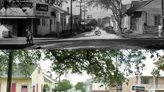
This three-credit class, taught by geographer and Senior Professor of Practice Richard Campanella, is offered each fall through the Tulane School of Architecture. Open to all with no prerequisites, AHST3131 is approved as an elective course for the New Orleans Center for the Gulf South’s Musical Cultures of the Gulf South major. The class explores how to analyze cities spatially, using New Orleans as a detailed case study. We will tackle this subject through lectures, discussion, field trips, film, research, and presentations. Students will apply these guiding geographical questions to urban places:

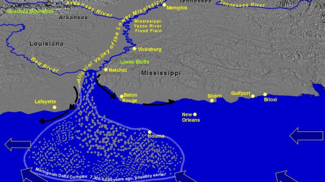
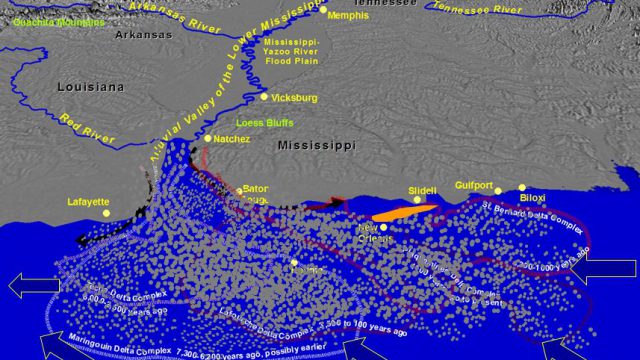
  • What is the shape, form, and origin of the city’s physical landscape?
  • How have humans transformed and manipulated that landscape into a cityscape?
  • How are phenomena spatially distributed or diffused, why, and how have those patterns changed over time?
  • How may we research, depict, characterize, and interpret those patterns?
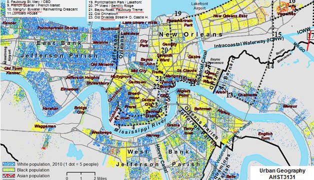
  • How are power, class, race, and inequity involved in use of space and the allocation of urban resources?
  • How can we use geographical knowledge to restore and improve disturbed places or patterns?
  • What distinguishes urban places from each other?
  • How do people create, occupy, perceive, and contest the use of urban space?
  • What clues do we see in the present-day cityscape that shed light on the above questions?

Prof. Campanella is the author of six critically acclaimed books on the geography of New Orleans, including Bienville’s Dilemma and Lincoln in New Orleans. His research has been praised in Southern History, Urban History, Places, Journal of the Abraham Lincoln Association, Louisiana History, and elsewhere. The only two-time winner of the Louisiana Endowment for the Humanities “Book of the Year” Award, Campanella has also received the Williams Prize for Louisiana History, the Mortar Board Award for Excellence in Teaching from Newcomb College Institute, and the Monroe Fellowship from Tulane’s New Orleans Center for the Gulf South. His next book, Bourbon Street: A History, will be released by LSU Press in 2014.

  • Richard Campanella

    Richard Campanella

    Geographer / Senior Professor of Practice

    Tulane School of Architecture geographer Richard Campanella is the author of six critically acclaimed books on the physical and human geography of New Orleans, as well as numerous journal articles and studies on New Orleans, historical geography, GIS, and remote sensing. The only two-time winner of the Louisiana Endowment for the Humanities “Book of the Year” Award, Campanella has also received the Williams Prize for Louisiana History, the Mortar Board Award for Excellence in Teaching from the Newcomb College Institute of Tulane University, and the Monroe Fellowship from Tulane’s New Orleans Center for the Gulf South.

    For more information, please visit RichCampanella.com

Course Chapters

  • 1 Class introduction and overview

    Class introduction and overview

    About This Chapter:

    In this opening class, we introduce geography as a discipline and urban geography as a sub-discipline. Using maps, case studies, and…

    • Back
    • Chapter 1 of 12
    • Next Chapter
    • Introduction

    • Readings

    • Photos

    Chapter 1 Class introduction and overview

    In this opening class, we introduce geography as a discipline and urban geography as a sub-discipline. Using maps, case studies, and an in-class experiment, we contemplate thinking spatially and analyzing the urban condition through a spatial lens. We also discuss the upcoming semester and research project, including data sources, and wrap up with student introductions and interests.

    Readings:
    Getis and Getis, Introduction to Geography (2007, selections)
    Campanella, Bienville’s Dilemma (2008, selection).

    • Urban Geography: New Orleans Case Study 1
    • Urban Geography: New Orleans Case Study
  • 2 Lecture: Forming the Landscape

    Lecture: Forming the Landscape

    About This Chapter:

    In this class we discuss how the Mississippi River Deltaic Plain of southeastern Louisiana formed, and its exceptional nature as a…

    • Back
    • Chapter 2 of 12
    • Next Chapter
    • Introduction

    • Readings

    • Photos

    Chapter 2 Lecture: Forming the Landscape

    In this class we discuss how the Mississippi River Deltaic Plain of southeastern Louisiana formed, and its exceptional nature as a river-dominated data. We continue with the geology, soils, hydrology, and topography of great New Orleans, using detailed thematic maps. The lecture then traces the origins of our coastal erosion, soil subsidence, and sea level rise crises, and illustrates the consequences using hurricanes Katrina, Gustav, and Isaac to illustrate. The class concludes with a discussion of coastal restoration, risk reduction, and the future viability of New Orleans.

    Readings:
    Lewis, “Axioms of the Landscape”
    Lynch, “The Image of a City”
    Getis and Getis, Introduction to Geography (2007, selections)
    Campanella, Bienville’s Dilemma (2008, selection).

    Readings:
    Lewis, “Axioms of the Landscape”
    Lynch, “The Image of a City”
    Getis and Getis, Introduction to Geography (2007, selections)
    Campanella, Bienville’s Dilemma (2008, selection).

    • Urban Geography: New Orleans Case Study 2
    • Urban Geography: New Orleans Case Study 3
  • 3 First Field Trip

    First Field Trip

    About This Chapter:

    For this class, we meet in front of Audubon Park at 10AM and, through a mix of rolling narration and disembarkations,…

    • Back
    • Chapter 3 of 12
    • Next Chapter
    • Introduction

    • Photos

    Chapter 3 First Field Trip

    For this class, we meet in front of Audubon Park at 10AM and, through a mix of rolling narration and disembarkations, learn the urban geography of New Orleans through this and other route stops: St. Charles Avenue, Uptown Reform Jewish community, “superblock nuclei” pattern, Napoleon Ave Wharf, Old Lafayette German/Irish area, River Garden/Hope/ “New Urbanism,” Lower Garden District, French Quarter / ”Little Palermo,” Marigny / Bywater; Lombard House, Industrial Canal, Lower Ninth Ward, Holy Cross riverfront; Jackson Barracks, St. Bernard Parish, Intracoastal Waterway/MR-GO, Vietnamese neighborhood, Chef Menteur Highway/Gentilly Ridge, Seventh Ward, Bayou St. John Plantation Houses/ Portage, Bayou Road/Esplanade Ridge, Rampart-Faubourg Tremé, Old Chinatown, Old Dryades/Central City, Claiborne back to Tulane.

    • Urban Geography: New Orleans Case Study 4
    • Urban Geography: New Orleans Case Study 5
  • 4 Lecture: Settling the Landscape

    Lecture: Settling the Landscape

    About This Chapter:

    After a discussion of geographical topics in news and current events, we discuss how cities come to be established at their…

    • Back
    • Chapter 4 of 12
    • Next Chapter
    • Introduction

    • Readings

    • Photos

    Chapter 4 Lecture: Settling the Landscape

    After a discussion of geographical topics in news and current events, we discuss how cities come to be established at their locations—principles of urban location, characteristics of urban sites and geographical situations, and a series of factors that explain most urban locations. We then delve into the details of how New Orleans came to be sited, 1682-1723. Students are also asked to announce their initial research paper topic ideas.

    Readings:
    Getis and Getis, Introduction to Geography (2007, selections)
    Campanella, Bienville’s Dilemma (2008, selection).

    • Urban Geography: New Orleans Case Study 6
  • 5 Lecture: Urbanizing the Landscape

    Lecture: Urbanizing the Landscape

    About This Chapter:

    Having “formed” and “settled” the landscape, now we urbanize it. In this class, we discuss principles of city structure and urban…

    • Back
    • Chapter 5 of 12
    • Next Chapter
    • Introduction

    • Readings

    • Photos

    Chapter 5 Lecture: Urbanizing the Landscape

    Having “formed” and “settled” the landscape, now we urbanize it. In this class, we discuss principles of city structure and urban form, and review technical terminology such as MSA’s, CBSA’s, conurbations, exurbs, census tracts, blockgroups, and blocks. We discuss data sets and challenges in measuring and mapping urban growth, including what the census offers and its limitations. For the second half of the class, we explore how, why, and where New Orleans expanded during 1700s-1900s, and conclude with a discussion of the relevance of the antecedent cadaster and antecedent axes in the cityscape.

    Readings:
    Getis and Getis, Introduction to Geography (2007, selections)
    Campanella, Bienville’s Dilemma (2008, selection).

    • Urban Geography: New Orleans Case Study 7
    • Urban Geography: New Orleans Case Study 8
  • 6 Lecture: Populating the Landscape,…

    Lecture: Populating the Landscape, Part I: the 1700s-1800s

    About This Chapter:

    Having “formed,” “settled,” and “urbanized” the landscape into a cityscape, now we focus on how humans distribute themselves across it, in…

    • Back
    • Chapter 6 of 12
    • Next Chapter
    • Introduction

    • Readings

    • Photos

    Chapter 6 Lecture: Populating the Landscape, Part I: the 1700s-1800s

    Having “formed,” “settled,” and “urbanized” the landscape into a cityscape, now we focus on how humans distribute themselves across it, in the form of residential settlement patters. We begin with the general principles on social areas of cities and a discussion of the geographies of nuisances, amenities, and hazards. We next investigate the complex historical ethnic/racial geographies of New Orleans, including Creolism, “back alley” patterns, the geography of slavery, and the formation of ethnic enclaves and cityscapes

    Readings:
    Getis and Getis, Introduction to Geography (2007, selections)
    Campanella, Bienville’s Dilemma (2008, selection).

    • Urban Geography: New Orleans Case Study 9
    • Urban Geography: New Orleans Case Study 10
  • 7 Lecture: Populating the Landscape,…

    Lecture: Populating the Landscape, Part II: the 1900s

    About This Chapter:

    In the second section of “Populating the Landscape,” we delve into the twentieth century and discuss segregation, integration, white flight, middle…

    • Back
    • Chapter 7 of 12
    • Next Chapter
    • Introduction

    • Readings

    • Photos

    Chapter 7 Lecture: Populating the Landscape, Part II: the 1900s

    In the second section of “Populating the Landscape,” we delve into the twentieth century and discuss segregation, integration, white flight, middle class exodus, suburbanization, public housing, modern ethnic/racial geographies, and post-Katrina patterns.

    Readings:
    Getis and Getis, Introduction to Geography (2007, selections)
    Campanella, Bienville’s Dilemma (2008, selection).

    • Urban Geography: New Orleans Case Study 11
    • Urban Geography: New Orleans Case Study 12
  • 8 Lecture: Populating the Landscape,…

    Lecture: Populating the Landscape, Part III: the 2000s

    About This Chapter:

    In the third section of “Populating the Landscape,” we introduce modern social-spatial topics nationwide, such as gentrification and displacement, the suburbanization…

    • Back
    • Chapter 8 of 12
    • Next Chapter
    • Introduction

    • Readings

    • Photos

    Chapter 8 Lecture: Populating the Landscape, Part III: the 2000s

    In the third section of “Populating the Landscape,” we introduce modern social-spatial topics nationwide, such as gentrification and displacement, the suburbanization of poverty, mixed-income housing, and the various views of Bloomberg’s New York. We then will watch and discuss the film, “My Brooklyn.”

    Readings:
    Mirabal, “Geographies of Displacement”
    Campanella, “Gentrification and Its Discontents”

    • Urban Geography: New Orleans Case Study 13
    • Urban Geography: New Orleans Case Study 14
    • Urban Geography: New Orleans Case Study 15
    • Urban Geography: New Orleans Case Study 16
  • 9 Lecture: Populating the Landscape,…

    Lecture: Populating the Landscape, Part IV: Contesting Urban Space

    About This Chapter:

    In this final “Populating” section, we explore how people interact spatially, move/diffuse across space, occupy urban space, and contest public space.…

    • Back
    • Chapter 9 of 12
    • Next Chapter
    • Introduction

    • Readings

    • Photos

    Chapter 9 Lecture: Populating the Landscape, Part IV: Contesting Urban Space

    In this final “Populating” section, we explore how people interact spatially, move/diffuse across space, occupy urban space, and contest public space. Neighborhood associations, NIMBY, noise ordinances, and gated communities are among the topics, as well as how citizens demarcate and identify neighborhoods, and how people perceive distinctions among cities.

    Readings:
    Campanella, “Neighborhoods as Evolving Perceptions”
    TJCampanella, “Jane Jacobs and the Death and Life of American Planning”

    • Urban Geography: New Orleans Case Study 17
  • 10 Second Field Trip

    Second Field Trip

    About This Chapter:

    Now we venture upriver and see the municipal water taps, batture community, Camp Parapet, River Road, Kenner riverfront, Destrehan Plantation, Ormond…

    • Back
    • Chapter 10 of 12
    • Next Chapter
    • Introduction

    • Photos

    Chapter 10 Second Field Trip

    Now we venture upriver and see the municipal water taps, batture community, Camp Parapet, River Road, Kenner riverfront, Destrehan Plantation, Ormond Plantation, Bonnet Carre Spillway.

    • Urban Geography: New Orleans Case Study 18
  • 11 Lecture: Devastating the Landscape

    Lecture: Devastating the Landscape

    About This Chapter:

    New Orleans has a nearly 300 year history of disaster and recovery. We review the reasons and responses to various floods,…

    • Back
    • Chapter 11 of 12
    • Next Chapter
    • Introduction

    • Readings

    • Photos

    Chapter 11 Lecture: Devastating the Landscape

    New Orleans has a nearly 300 year history of disaster and recovery. We review the reasons and responses to various floods, hurricanes, epidemics, wars, and fires, starting with the Mississippi River flood of 1719 and Hurricane Katrina deluge of 2005.

    Readings:
    Getis and Getis, Introduction to Geography (2007, selections)
    Campanella, Bienville’s Dilemma (2008, selection).
    Times-Picayune, “Shrinking Cities”

    • Urban Geography: New Orleans Case Study 19
    • Urban Geography: New Orleans Case Study 20
  • 12 Lecture: Restoring the Landscape

    Lecture: Restoring the Landscape

    About This Chapter:

    In this penultimate class, we study the recovery of New Orleans after the Katrina deluge, covering topics such as “the great…

    • Back
    • Chapter 12 of 12
    • Next Chapter
    • Introduction

    • Readings

    • Photos

    Chapter 12 Lecture: Restoring the Landscape

    In this penultimate class, we study the recovery of New Orleans after the Katrina deluge, covering topics such as “the great footprint debate,” “plandemonium,” the right to return, coastal restoration and risk deduction, and axioms of urban resilience.

    Getis and Getis, Introduction to Geography (2007, selections)
    Campanella, Bienville’s Dilemma (2008, selection).
    National_Geographic, “A Perilous Future”
    Vale, “Resilience City: Axioms of Resilience”

    • Urban Geography: New Orleans Case Study 21
    • Urban Geography: New Orleans Case Study 22